
Yamazaki Kinbe, Edo et Asana Yahei, Osaka, 5th year of the Tenmei period (1785).
Large wood-engraved map of 165 x 91 cm (65 x 35,8 inches), entirely hand-colored at the time. Red ink stamp in the bottom. Folded and preserved in a modern blue cloth protection case. Very good condition.
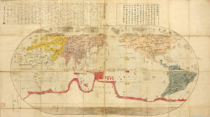
First edition of this superb and rare map of the World published in Japan in 1785, showing the progress of the Japanese geographical and cartographical knowledge at the end of the 18th century.
Nagakubo Sekisui 長久保赤水 (1717-1801) is the most famous Japanese cartographer of the end of the 18th century.
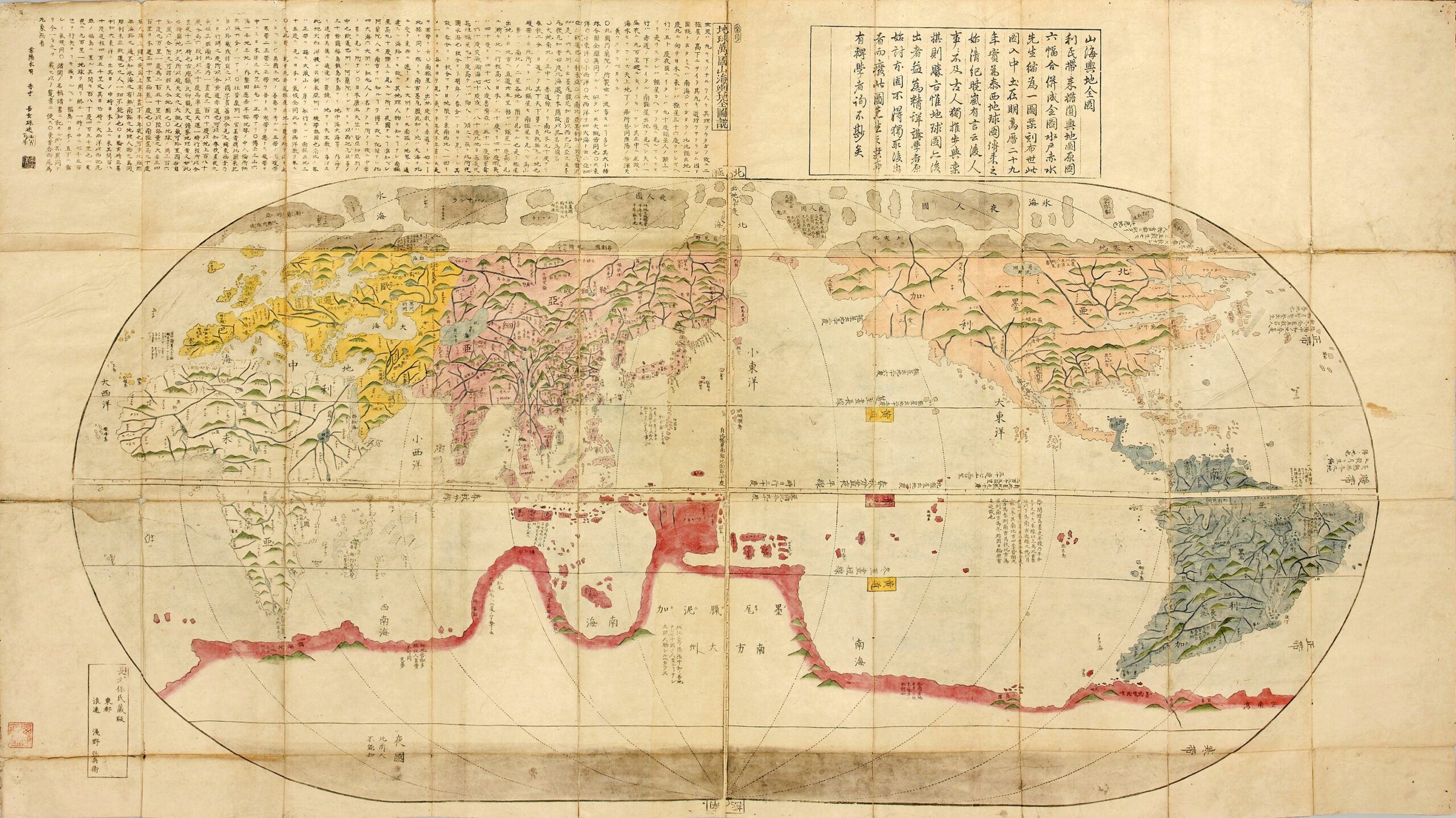
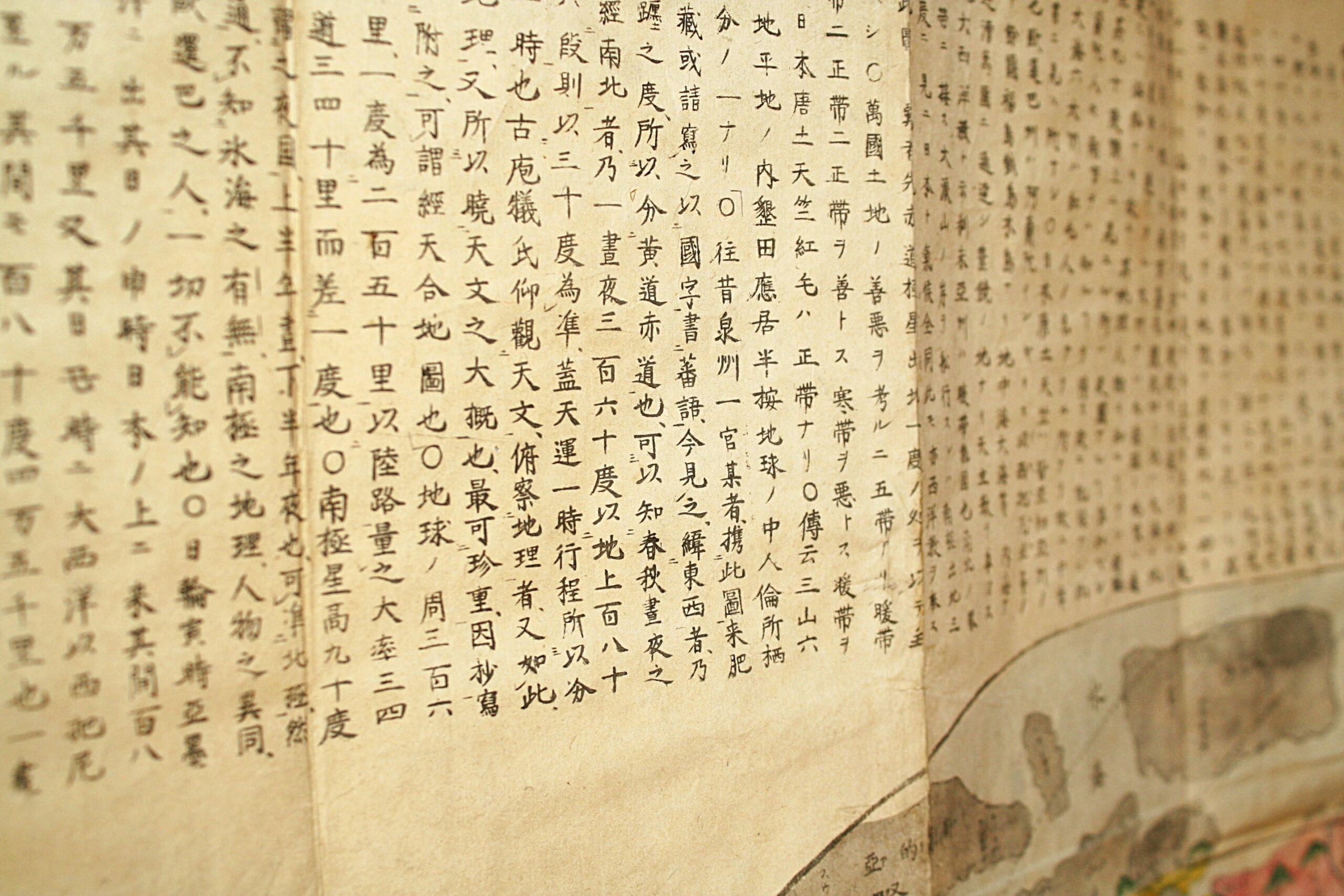
This map presents a lot of information: at the top right, a cartouche encloses a text in classical Chinese by Katsuragawa Hoshu (1751-1809), famous doctor at the Shogun court, knowing Dutch and passionate about sciences and European cartography.
At the top left, another cartouche presents 70 lines of text in Japanese written by the author of the map, with explanations as for the contribution of Dutch science to the theory of the geographic illustration of the spherical earth. At the bottom left, in a third cartouche, appear the name of the author: Nagakubo Sekisui and the names of the editors of the map: Yamazaki Kinbe, Edo and Asana Yahei, Osaka.
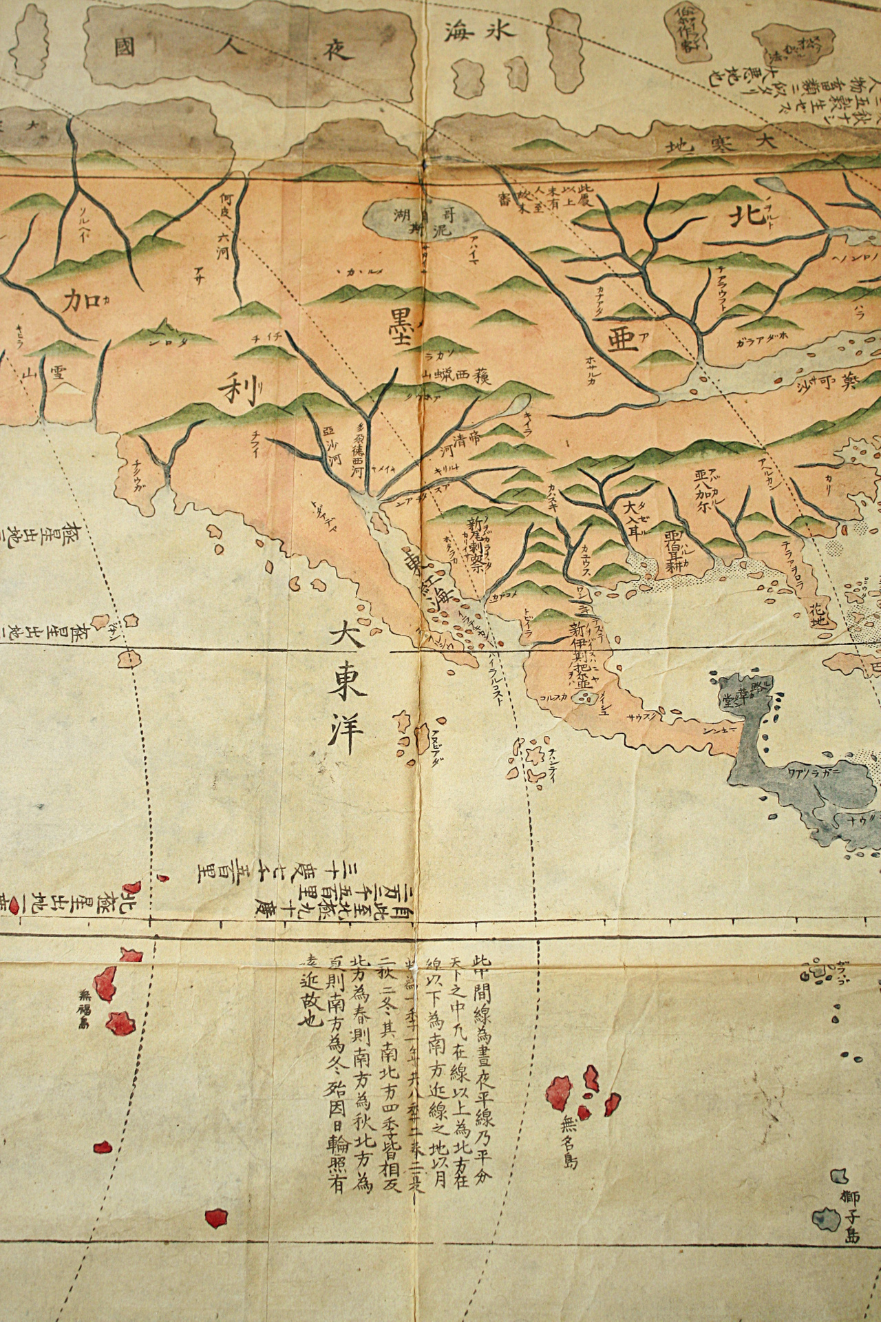
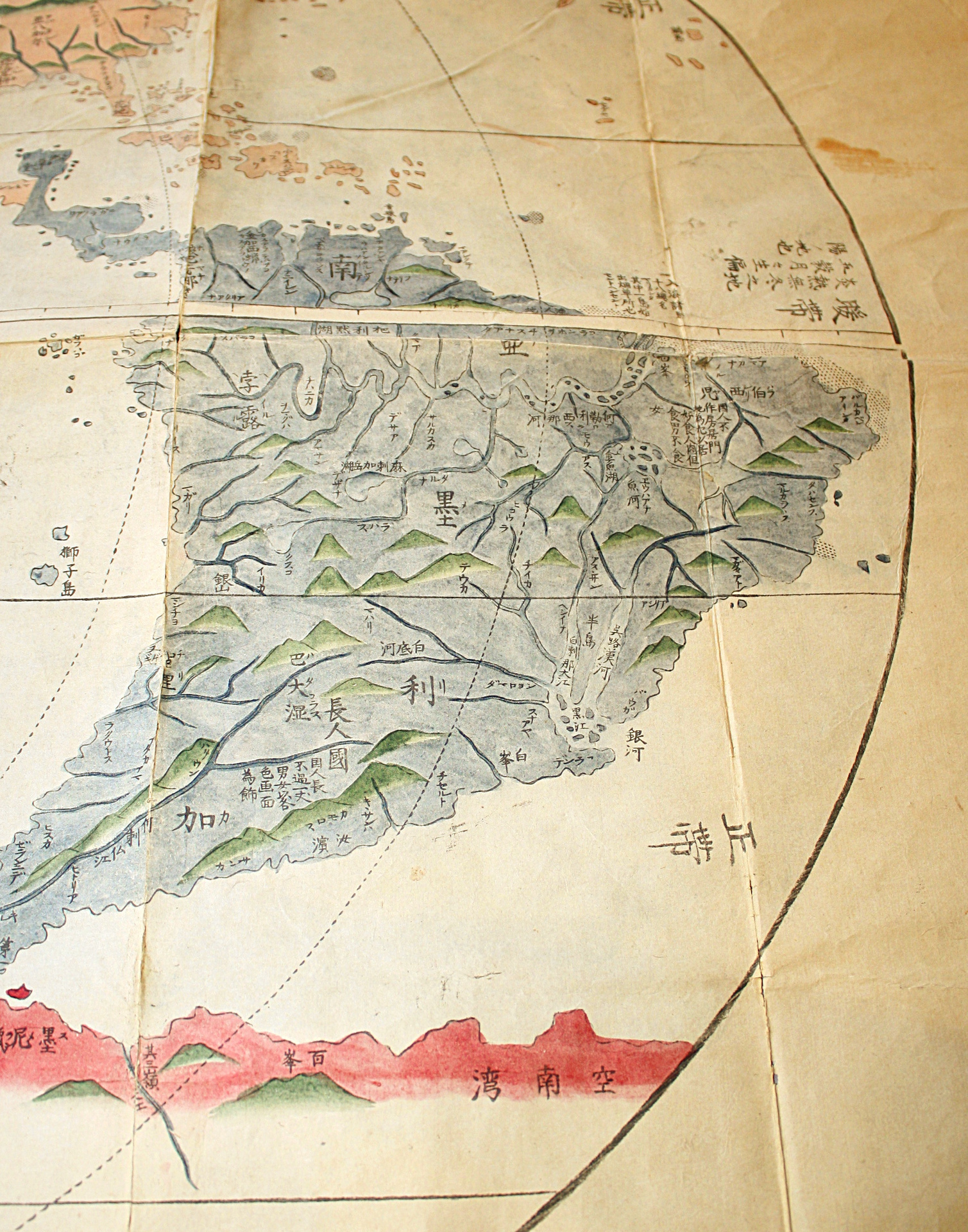
· At first sight, the map seems to be a simplified copy of the very famous map of the world that Matteo Ricci (1552-1610) had presented in 1602 to the Ming emperor, Shenzong.
After the triumph of Protestantism in the middle of the 16th century, the Catholic Church tries to react and send missionaries, first Jesuits, in the Far East, in order to convert the inhabitants of these empires to Christianity. Ricci leaves Rome in 1577 and, via Lisbon, arrives in China in 1583. He has the idea that conversion needs to be carried out through a demonstration of the superiority of the European sciences. The Chinese consider themselves in the middle of the earth (China = middle empire), which has a square shape. Ricci quickly learns Chinese and with the help of the first converts, publishes two editions of maps of the world: in 1584 and in 1600. No copy of these maps has survived. He bases his judgment on European sources: Clavius, Ortelius, Ramusio, Piccolomini, Ptolemy, etc. He disrupts the conventions of the time. In order to avoid deception, he illustrates China and Japan in the middle of these maps and rejects the American continent to the Far East. However, even this trick displeases the Chinese mandarins who still believe that their country represents 75% of the earth. In 1601, Ricci arrives in Beijing and draws a third augmented edition, which he presents to the emperor. Of this edition, 7 copies printed in Beijing in 1602 have survived.
The Jesuits had also sent some copies of this map to Japan where the Portuguese religious were also exercising their missionary activity. Until their first contacts with the Europeans, the Japanese were dependent on the knowledge imported from China.
Matteo Ricci’s map has had a considerable influence in Japan. Our copy proves that Nagakubo Sekisui was largely inspired by it.
· Comment on this map of the world, by Nagakubo Sekisui:
Nagakubo draws his map, like Ricci, in an oval shape.
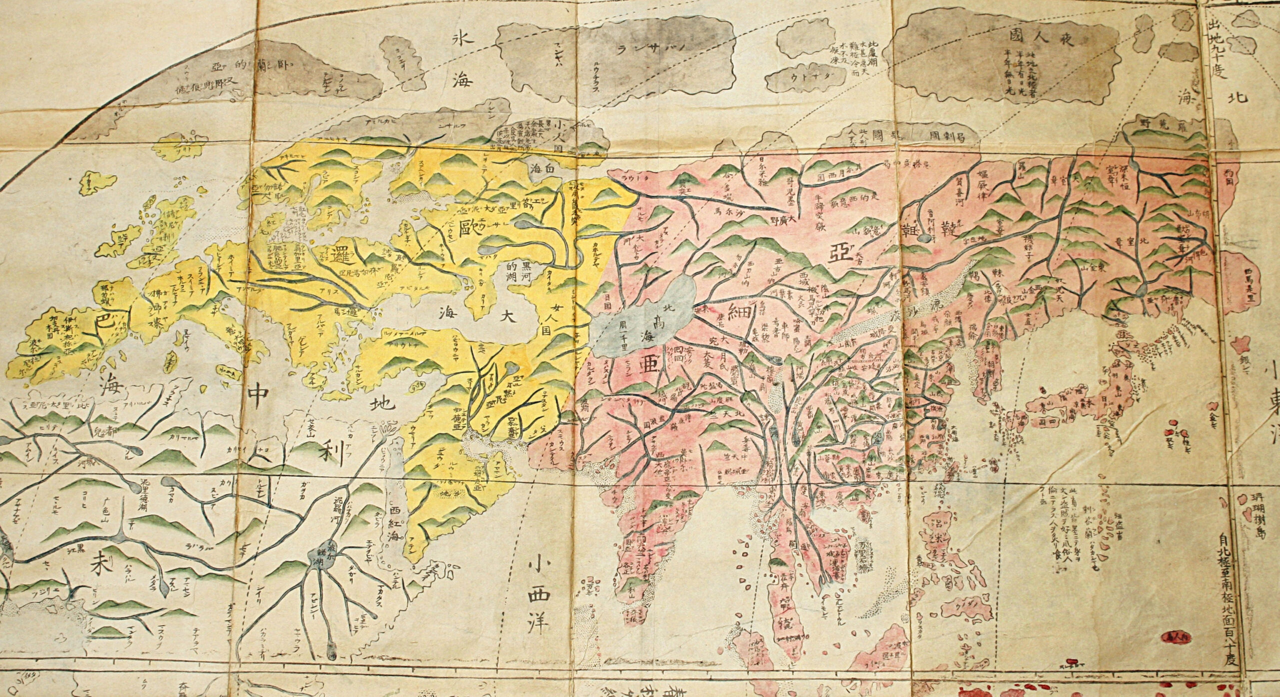
He uses different colors for the continents and copies the details of Europe, Africa, Central Asia and the two Americas. However, compared to Ricci, he considerably improves the illustration of Japan and South-East Asia. In accordance with the Chinese customs, Ricci’s map was covered with long explanatory comments. Nagakubo deletes most of them and keeps only a few. He divides the equator into 72 units, each representing 5° of longitude but only draws 12 arches, each corresponding to 30°. The illustration of longitudes, corresponding to a spherical Earth, was still new in Japan.
This map comprises a very interesting detail: it illustrates two imaginary islands: Kinshima (金島 the golden island), in the east in the Pacific, at the same latitude as Kyoto, and Ginshama (銀島 the silver island), pretty far from Ezo (now Hokkaido). These imaginary islands have played an important role because the Spanish first, then the Dutch, have sailed in vain during all 17th century in the Pacific searching for them. These islands aren’t illustrated on Ricci’s map but they are present on old maps representing Japan.
Texts printed on the map:
The map generally keeps the Chinese characters invented by Ricci in 1602 but Nagabuko often transforms them into Japanese characters. As the pronunciation of Chinese characters is different in China and Japan, a lot of names are difficult to interpret today and require imagination.
Text n°1 (placed just south of the equator at the longitude of California, 95 characters in Chinese:
“This median line divides the Earth into two parts of equal dimensions. All that is above this line is called the Boreal Region and on the contrary all that is below this line is called Austral Region. The adjoining regions of this zone have seasons that last a month and a half. So around the equator each year there are eight seasons: two springs, two summers, two autumns and two winters. The four seasons north and south of this line are always the opposite. When in north this is spring, in south this is autumn. The reason of this phenomenon can be explained by the proximity or distance from the solar light.”
Text n°2 (placed on different latitudes): 1. +65° and -65° cold zone; 2. +40° and -40° cold zone; 3. On the equator torrid zone.
Text n°3 (tropic of Capricorn and tropic of Cancer: yellow road 道黄, equator: red road 道赤).
Text n°4 (Brazil on the map): “The inhabitants of this country don’t build houses. They dig the earth and live in caverns. They like to eat human flesh. However, they eat only men and not women. Their clothes are made from birds’ feathers.”
Text n°5 (inscriptions on the French territory): Nahara (Navarre), Marusenia (Marseille), Goariya (Gaul). France is phonetically designated by the three characters 拂郎察 (Fu Lang Cha).
Very beautiful map of the World, very rare, published in 1785, entirely hand-colored at the time in the editor’s workshop, very well preserved.
References: Nanba, M., Muroga, N. and Unno, K., Old maps in Japan, 1976, p.15; Cortazzi, H., Isles of Gold: Antique Maps of Japan, 1984, p. 35.