Lyons, Melchior and Gasper Trechsel, 1535.
Folio [390 x 270 mm]: (4) pp., (180) pp., 50 maps, (75) pp. Errata leaf remounted. Red morocco, gilt double fillet and border on the covers, gilt pomegranate fleurons in the center and on corners, flat spine identically decorated (rebacked preserving original spine), blue endpapers, gilt edges. 18th century binding.
First edition of Ptolemy’s Geography edited by Michael Servetus in Lyons in 1535. It is rare.
Baudrier, XII, 250 ; Mireille Pastoureau, Les Atlas français, XVIe-XVIIe siècles, pp. 380-381 ; Alden & Landès, 535-14 ; Philipps, Atlases, 364 ; Sabin 66483 ; Harrisse 210.
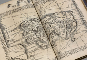
The work divides into three parts; the text, comprising the new Latin translation by the humanist Wilibald Pirckheimer (1470-1530), edited by Michael Villanovanus, known as Servetus (1511-1553); the maps and the index.
The present edition is illustrated with 49 large double-page maps and full-page map.
27 of the maps depict the ancient world and 22 the new world, with one map of Lotharingia.
The maps are printed from unaltered blocks used in Lorenz Fries’s edition printed by Grüninger in 1522 (the final map is captioned with this date and Fries‘s initials), in Grüninger’s Strasbourg edition of 1525.
Four of the maps, including two maps of the new world, relate to the Americas.
Several of the maps in this edition, including that relating to the Holy Land, are printed without their descriptive text on the versos, indicative of the effect of Calvinism, which meant that many copies of the earlier editions were burnt on Calvin’s orders. Michael Servetus, a Spanish theologian and physician, was burnt at the stake in 1553, condemned by Calvin for his doctrinal heresies.
“One piece of evidence used against Servetus was the passage on the back of map 37 [Palestime], where it is explained that ‘Palestine was not such a fertile land as was generally believed, since modern travelers reported it barren.’ This was not Servetus’s original view, but copied from the 1525 [Pirckheymer] edition” (Nordenskiölk Collection 2, pp. 166-167).
Some illustrations were engraved after drawings by Durer and several maps represent parts of America.
Very attractive copy of this sought after work, very fresh, with the title ruled in red and decorated in red and green watercolor, hard to find in 18th century red morocco binding.
It comes from the princely library of the Liechtenstein with engraved ex libris.
![Geographicae enarrationis libri oct. Traduit par Wilibald Pirckkeimer. Edité par Michael Villanovanus [Servetus].](https://www.camillesourget.com/wp-content/uploads/2023/03/005-b-bt150161-012-kWE8r.jpg)
![Geographicae enarrationis libri oct. Traduit par Wilibald Pirckkeimer. Edité par Michael Villanovanus [Servetus]. - Image 2](https://www.camillesourget.com/wp-content/uploads/2023/03/005-b-bt150161-012-2iASn.jpg)
![Geographicae enarrationis libri oct. Traduit par Wilibald Pirckkeimer. Edité par Michael Villanovanus [Servetus]. - Image 3](https://www.camillesourget.com/wp-content/uploads/2023/03/planche-1-zH7QE.jpg)
![Geographicae enarrationis libri oct. Traduit par Wilibald Pirckkeimer. Edité par Michael Villanovanus [Servetus]. - Image 4](https://www.camillesourget.com/wp-content/uploads/2023/03/titre-yrXea.jpg)
![Geographicae enarrationis libri oct. Traduit par Wilibald Pirckkeimer. Edité par Michael Villanovanus [Servetus]. - Image 5](https://www.camillesourget.com/wp-content/uploads/2023/03/005-a-bt150161-011-0hR0X.jpg)