Dated: 寛延庚午, Kanen, year of the horse = Kanen 3, 1750.
Edited by the Qing Dynasty scholar Lu Yunhan, 呂君翰, published by Suwaraya Mohei, 須原屋茂兵, at Edo.
Original blue paper covers preserved in a floral decorative case [21 x 30,5 cm].
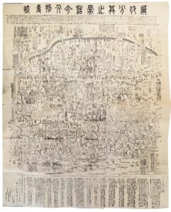
181,5 x 168,5 cm
This is a huge folding map in an excellent state of conservation. The map is very rare. One copy was brought back to Europe by Siebold and is available at Leiden University Library, the Netherlands. Two other copies are known in western collections: A. in a German library as described by Eva Kraft in 1982 and B. the Beans collection at the University of British Columbia at Vancouver, Canada, (see bibliography).
The single original printed map of Lu Junhan, much smaller than our map, 136 x 124 cm, dated 1679, is nowadays known in only the Bodleian Library copy at Oxford.
Our comprehensive, administration division map can be regarded as a historical material of great value. It is a valuable reference source for the study of the historical geography at the end of the Ming , 1368 – 1644, and at the beginning of the Qing periods, 1644 – 1912. It finely illustrates China’s two imperial capitals: the northern capital Beijing, 北京, and the southern capital Nanjing, 南京, the thirteen provinces, the Great Wall, (literally the “Ten-Thousand Mile Long Wall”, 萬里長城) in doted lines, the two major rivers, the Yangtze, 長江and the Yellow river or Huanghe, 黃河, and their tributaries, the Dongting Lake, 洞庭湖, in Hunan Province, China’s largest source of sweet water, the Grand Canal, 京杭大運河, the world’s longest artificial waterway, built around the beginning of the 7th century, connecting the 1700 km distant cities of Beijing and Hangzhou, 杭州, as well as the holy Taoist and Buddhist Mountains. The birth place of Confucius, (Kong Zi in Chinese, 孔子) 551 – 449 BC., Qu Fu, 曲阜, is clearly indicated in Shandong Province. Longitudes and latitudes are not shown. After Matteo Ricci’s stay in Beijing, between 1600 – 1610, a few maps made by Chinese scholars were drawn with meridian lines and latitudes, but those authors did not fully understand their scientific content. Since travelling during the period concerned primarily occurred via the river network, trade routes are not shown on the map. The long text at bottom of the map describes the two capitals and the thirteen provinces of the China, including their names, production of rice, wheat, raw and processed silk, cotton, copper, horse fodder and salt, etc., as well as the distances between the provinces.
The illustration of the mouth of the yellow river on our map is of particular interest. The long river, cradle of the Chinese civilization, is known to have changed its pathway several times during the past two thousand years. Currently, it flows eastward on the north side of Jinan, 濟南, the capital of Shandong Province, 山東, discharging in the Bohai Sea, 渤海. Our map illustrates the mouth of the river further south, in Jiangsu Province, 江苏. Rather than a cartographic error, the path of the river results from its frequent dramatic changes. The river took its present course as late as the second half of the nineteenth century.
On the eastern edge of the map long texts are devoted to the description of the history of Japan,
日本, and Korea, 朝鮮, as well.
Japanese reprint of a map printed in Henan in 1679, folds down to be 21 x 30,5 cm., woodblock printed.
An exceptionnaly rare wall-size of China. excuted by Shaolin Zen master.
The Shaolin Xi [Monastery/Temple] is a Chán [Zen] Buddhist temple at Song Shan near Zheng Zhou City, Henan Province in Dengfeng, China. It was led by Venerable abbot Shi Yongxìn. Founded in the 5th century, the monastery has been famous for centuries its association with Chinese martial arts and particularly with Shaolin Kung Fu. It is also a Mahayana Buddhist monastery perhaps best known to the Western world. The Shaolin Monastery and its famed Pagoda Forest were inscribed as a UNESCO World Heritage Site in 2010 as part of the Historic Monuments of Dengfeng.
A rare edition: Reprinted and published in Japan by Katsuragawa Hosan in 1750, reproduced from the Chinese original of Kangxi 27 [1679]. The original Chinese edition has been exceptionally obscure and impossible to come by for over the last two-hundred years and is believed now to be lost to posterity.
Printing technique and the paper: The work is woodblock printed by hand on hand-made Washi paper.
Chinese view of ancient China: This grand scale work covers a very large space and is quite handsome, suitable for framing and display. The map shows a full view of all of China, from the Great Wall in the North, Shanghai, the East coast, down to the oceans in the South and Hainan Island, and the coasts along the Eastern shores. This is a spectacular work, showing each province, with outlines, large numbers of place names, rivers & the major waterways, mountains named and located to show all of the known lands considered a part of China, delineating the country and its exterior boundaries. Japan and other islands are not shown, but boxes with notes in Chinese as to their existence and location are well documented. The lower portion has text discussing the population of the various provinces and other notes. Areas beyond the traditional lines of China, i.e.: North of the Great Wall, and to.
Rarity of the map and its makers: This grand-scale and truly spectacular work is virtually never found on the market. The Shaolin Monastery monks were the original founders of the celebrated and now famous Kung-fu martial art school, located in Henan province. The priests were legendary and the most feared for their martial art prowess. They were also covert with their powerful political force in China.
Shaolin si [temple/monastery] legendary customs: Priests who passed the highest level of Kung-fu martial art were invited to participate in a recognition ceremony. They were allowed to self-brand themselves by picking up a red-hot iron brazier that had long temple dragon decorations on the sides. The branding was accomplished by clamping the brazier between their forearms until the dragon image was branded on them. Another ancient practices used was the Jieba. It is an ancient ceremony where nine marks are burned onto the head with sticks of incense. In 2007 the Chinese government partially lifted the 300-year ban of the Jieba, allowing the the mentally and physically prepared to participate in the ancient tradition. Incense or moxa was used on top of the shaved head and burned in a ceremony of dedication to the Shaolin Si [temple/monastery] by the most skilled of martial artists.
Bibliography:
- Kerlen, Catalogue of Pre-Meiji Japanese Books and Maps in Public Collections in the Netherlands, Gieben, Amsterdam, 1996, p. 543, n°1320.
Li Xiaocong, Catalogue of pre-1900 Chinese maps seen in Europe, Beijing International Culture Press, 1996, pp.158-159.
- Kraft, Japanische Handschriften und Traditionelle Drucke aus der Zeit vor 1868, Wiesbaden, 1982, vol. 1.