
Lithographed & Published by The Peiyang Press, Ltd., Tientsin-Peiping, 1936.
8vo of (1) title-page, 22 pp. of explanatory text and a folded map in colors measuring 86 x 74 cm. Two small tears in the white margin of the map. Preserved in the original publisher’s wrappers and slipcase.
Booklet’s dimensions : 181 x 132 mm.
Map’s dimensions : 860 x 740 mm.
Very rare first edition, complete with the folded map and the booklet, preserved in the publisher’s illustrated folder.
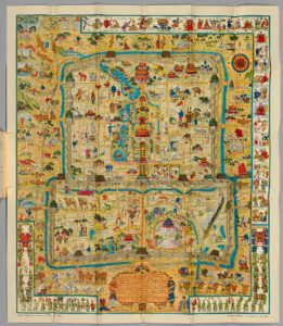
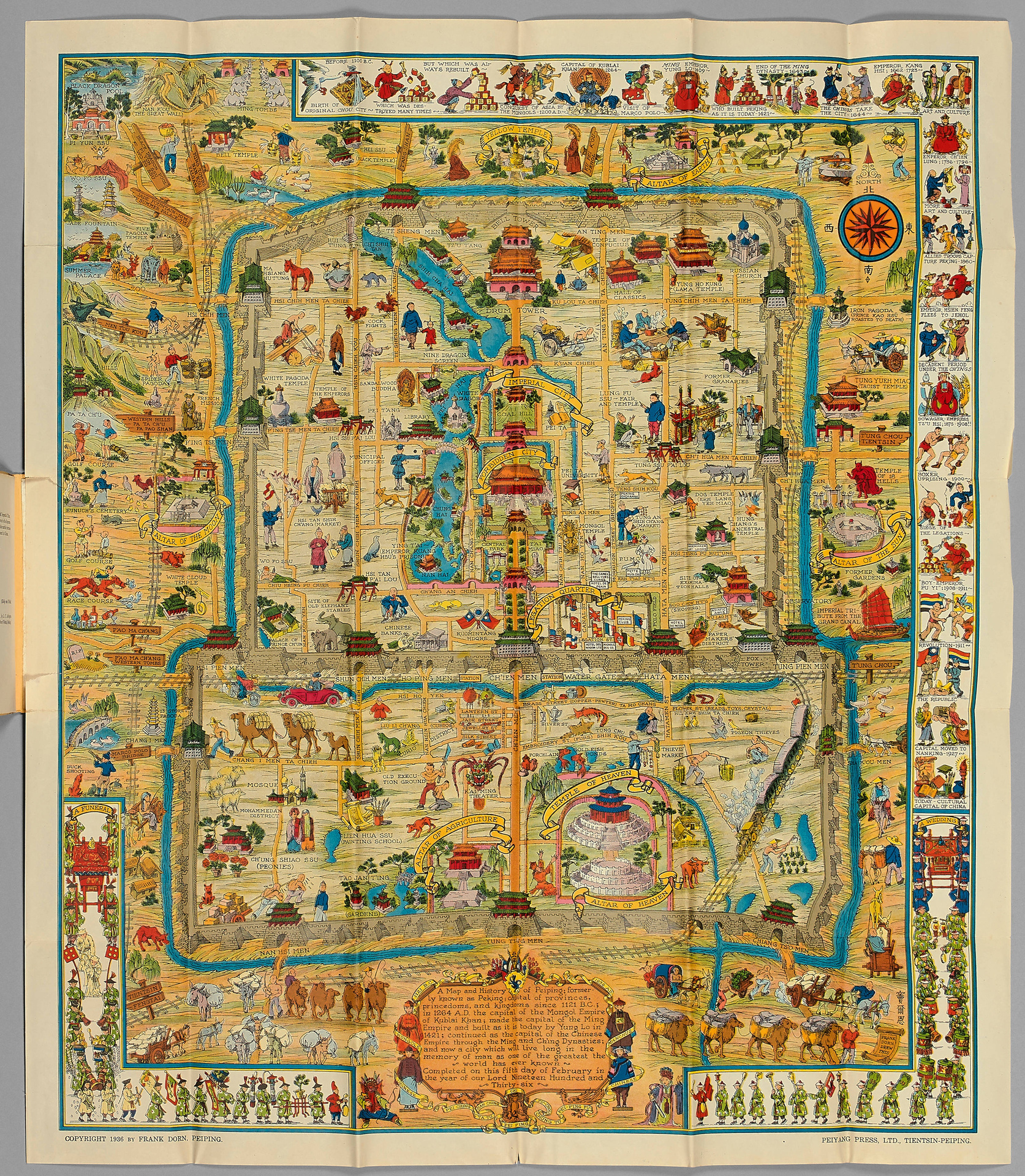
Finely executed pictorial map of Beijing, published by Frank Dorn and the Peiyang Press. Ltd. of Tientsin and Peiping, in 1936.
Dorn’s map is perhaps the best known and most iconic pictorial map of Beijing published in the 20th Century, offering a host of interesting ethnographic and iconographic information about Beijing and its environs, while retaining the whimsical qualities of the great pictorial maps of the first half the 20th Century.
Dorn’s map is considered one of the great maps of the golden era of pictorial mapmaking.
The map is ringed with a series of cartoon vignettes illustrating the history of the city from ancient times to 1936. Dorn was a friend and admirer of the pictorial mapmaker Jo Mora (1876-1847), and was clearly influenced by Mora’s style of combining accurate pictorial details, bright colors and a bit of whimsy, along with vignettes providing an illustrated history of the place.
The cartouche is decorated with names and dates of historical events and this legend in the center.
Frank Dorn was an artist, writer and military officer. Growing up in San Francisco, he attended the San Francisco Art Institute and became an accomplished cartoonist. After graduation from West Point, he was assigned a post in the Philippines, and as a side project wrote a book about a clan of tribal people he got to know there. An acquaintance of California artist Jo Mora, Dorn began making his own maps; an early one depicted Camp Strassenbourg in the Philippines.
While living in China, Dorn made his popular pictorial map of “Peiping”. He later served in the field as advisor to a Chinese army. A fluent speaker of Chinese, Dorn’s most important military role was in the China-Burma-India theater during World War II. There he served with Deputy Chief of Staff of the U.S. Army forces, General “Uncle Joe” Stilwell, during the Burma campaign from 1942 to 1944, and served as a commanding officer in 1944-45. A 1942 Life Magazine article about the Burma mission stated that, “Dorn, an artist, drew Stilwell’s campaign maps.”
Dorn eventually attained the rank of Brigadier-General and retired in 1953. He settled in Carmel, California, living what his friend John Thompson describes as “a semi-bohemian life, writing and painting. In the Sixties he did some amazing psychedelic paintings, wondered if he was the incarnation of a Buddhist painter, and held progressive civil rights and antiwar views.” In the 1970s, Dorn authored two highly-regarded scholarly books on the Chinese and Burmese theaters of World War II.
A fascinating pictorial map of Beijing, drawn by an American officer who was a military attaché in China during the 1930s.
It features vignettes of Chinese history from 1100 BC to 1927 as well as modern tourist attractions including golf and race courses.
Hints to the political situation include the ‘Kuomintang Headquarters’; and the German swastika and the Japanese ‘Rising Sun’ flags flying in the ‘Legation Quarter’, the year before the official start of the Second Sino-Japanese War in 1937.
Frank Dorn (1901-81) was a graduate of West Point (where he picked up the life-long nickname of ‘Pinky’), before being posted to Beijing in 1934 to help gather intelligence on Japanese aggression. He immersed himself in the language and culture of the city, researching the Forbidden City and collecting antiquities. When war with Japan broke out Dorn became chief-of-staff to L.t General Joseph Stilwell, with a rank of Colonel. At one point relations between the Americans and the leader of the Chinese Kuomintang, Chiang Kai-shek, were so bad that Dorn was ordered to prepare a plan to assassinate him. Although Dorn suggested giving Chiang a faulty parachute and sabotaging his plane authorization was never given.
The plan is packed full of wonderful illustrations, from the border that covers the city’s history from its inception in 1100B.C., its numerous dynasties – including the ‘decadant period under the Ch’Ings’ – through to the revolution of 1911 and the movement of the capital to Nanking in 1927. Also to the borders are illustrations of a wedding and a funeral.
The plan itself not only shows all the historic landmarks, including the Forbidden City, and the Temple and Altar of Heaven but also the racecourse, zoo, old execution ground, and cocks fighting.
The color printed map is accompanied by a 22 page booklet which gives a potted history of the city together with a list of points of interest that are shown on the map.